|

A single-site license allows a user access to ONE gegraphical area on the CDROM. Access to additional areas are an additional cost.
RECON-Pro Keypad & Stylus Demonstration
* Please contact Long Beach Dive, or Garmin to verify the exact chart area you require is available.
|
|
|
|
|
|
Garmin BlueChart Software/PC Hardware Pricing
Garmin BlueChart Software as described above, is currently priced at :
| Garmin BlueChart
|
CDROM or License |
Cost |
|
| Americas |
Single-site license and Americas CDROM w/Charts |
US$ 130.00 |
|
|
Additional site license (Americas) |
US$ 90.00 |
|
| Atlantic |
Single-site license and Atlantic CDROM w/Charts |
US$ 200.00 |
|
|
Additional site license (Atlantic) |
US$ 150.00 |
|
| Pacific |
Single-site license and Pacific CDROM w/Charts |
US$ 175.00 |
|
|
Additional site license (Pacific) |
US$ 115.00 |
|
|
|
|
|
|
|
|
|
| Garmin Blank DataCard |
64MB |
US$ 75.00 |
|
|
|
|
|
| Garmin PC DataCard Writer |
USB |
US$ 50.00 |
|
| - Or - |
|
|
|
| Garmin Pre-loaded DataCard |
1 area & license pre-loaded on a data card. |
US$ TBD |
Call for pricing |
|
|
|
|
|
|
|
|

 GPS Software GPS Software
By combining the use of GPS software and one of Long Beach Dive's underwater navigation products in your dive-plan, tasks can be completed quickly and accurately by maintaining detailed records and logs of your dive, while saving time and air.
- Various PC software packages are available from GPS manufactures and third-party developers which can assist in pre-dive planning as well as post-dive analysis.
- The examples shown below use the "GPS Utility" software package from GPS Utility Limited to demonstrate the use of GPS software to aid in the completion of several common underwater tasks.
- For detailed information on GPS Utility, including download and licensing instructions please visit: www.gpsu.co.uk/index.html
|
|
|
|
GPS Software Applications
The GPS Utility* is a PC software package used for managing, mapping and manipulating GPS information (waypoints, routes and tracks). It can be used for transferring data between a computer and a large range of GPS receivers. It will convert geographic coordinates between many different datums and grid systems. GPS Utility also combines many useful data analysis, processing and reporting tools with an extensive range of import and export facilities.
*It is important to note, the capabilities of products such as GPS Utility go far beyond the examples shown below. Please refer to the products for a complete description of features and capabilities.
|
|

|
|
|
|
Recreational Diving
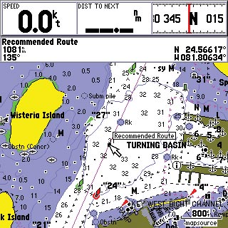
During pre-dive planning create and map waypoints using your GPS receiver and personal computer software such as GPS Utility.
|
|
|
|
|
|
- While on the dive follow the pre-dive plan using the previously entered waypoints. This will save time and air during your dive.
|
|
|
|
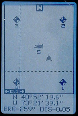
- Use GPS software to create waypoints representing the dive boat and dive area.
- Upload these coordinates into your GPS receiver and navigate directly to and from the boat using your GPS receiver's display.
|
|
|
|
|
|
|
|
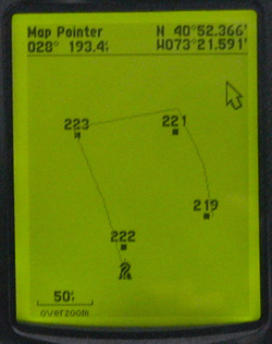
- Plot perimeter waypoints of the dive area and navigate around or within the points. Plot the location of underwater objects and return to the objects location at a later time.
|
|
|
|
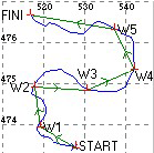
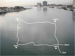
- Detailed position information can be downloaded from the GPS receiver after a dive, including the divers track.
- The track and waypoints can then be superimposed and calibrated on a graphic or picture of the body of water for later analysis of the dive area.
|
|
|
|
|
|
Search and Recovery
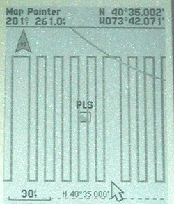
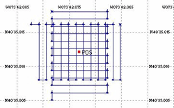
Using GPS Utility software with the RECON Pro or Accu-Dive Pro adds many advantages to a search and recovery dive. By creating a predetermined search grid pattern on your GPS receiver using GPS Utility software, you are able to search more area using less equipment and manpower. By defining search boundaries on the surface, you can use your GPS receiver for low-visibility searches without disturbing the bottom with search lines.
An electronic record of the searched area can be maintained by using the trail function of your GPS receiver, and the GPS Utility search-grid.
|
|
|
|
|
|
|
|
|
|
|
|
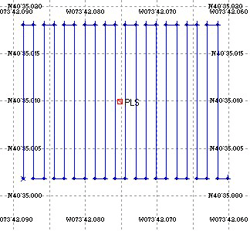
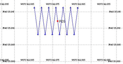
Create Zigzag, square, or rectangular search patterns automatically.
|
|
|
|
- Download search patterns into your GPS receiver prior to a search and recovery dive and search underwater locations quickly and accurately.
|
|
|
|
|
|
|
|
|
|
|
|
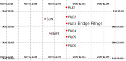
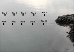
Underwater Surveys
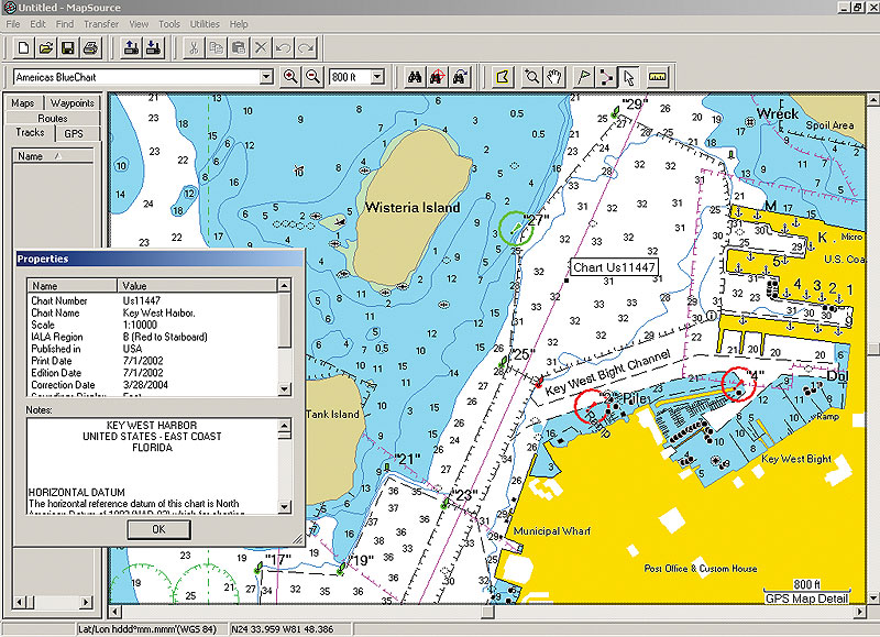
Conduct surveys of underwater obstacles, dredged areas, and reef locations, or document other underwater areas of interest. Plot the locations of multiple underwater objects, such as pilings or pier and bridge foundations.
|
|
|
|
- The waypoints representing the underwater object can then be superimposed and calibrated on a graphic or picture of the body of water for later analysis and documentation.
|
|
|
|
|
|
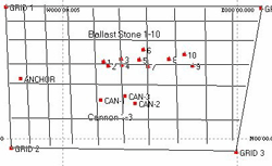
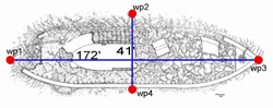
Underwater Archeology
A useful tool for the exploration and documenting of shipwrecks, old harbors, anchorages, coastal inns, or ancient coastal settlements. Use PC software to extrapolate detailed underwater site measurements and distances between plotted objects.
|
|
|
|
- Detailed position information can be downloaded from the GPS receiver after a dive, including the location of objects plotted as waypoints while underwater.
|
|
|
|
|
|
|
|
- Extrapolate distances and bearings between objects (waypoints) mapped underwater using the GPS Utility - Identify/Measure tool.
|
|
|
|
|
|
|
|
|